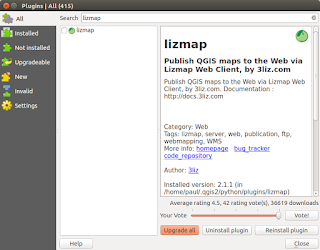
This post follows on from my previous three (most recent first in list) linked below. There is no doubt that in just a short time from now we will probably see a 'one-click' installer to by-pass the next steps but a least this method allows you to change 'in/out' the individual libraries if there is are updates using the usual ' sudo apt update && sudo apt upgrade '. http://www.paulshapley.com/2016/08/qgis-server-bringing-map-into-browser.html http://www.paulshapley.com/2016/07/how-to-install-qgis-server-on-ubuntu.html http://www.paulshapley.com/2016/04/how-to-install-postgresql-95-and.html 1. Firstly...Create a new QGIS project, add your layers from PostGIS, Shapefiles or raster (geotiff), style and symbolise those layers, set the projection and ensure you've set up your 'OWS Server' in 'Project Properties'. 2. Let's install the 'Lizmap' Plugin first by going into the 'Plugins' menu then 'Manage...
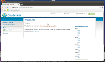
It's quite easy to find installation instructions for most Ubuntu versions but it's nice to check they still apply to the most recent release (15.04 at the time writing). I tested this yesterday and it still works for me. My thanks to Hongru Hou (link at the end of the article for full details). Install Apache2 (if not installed):- sudo apt-get install apache2 sudo apt-get update Test Apache2 web server is working:- sudo /etc/init.d/apache2 start sudo /etc/init.d/apache2 stop sudo /etc/init.d/apache2 restart Install Java 7 using the 'Webupd8team' repository:- sudo add-apt-repository ppa:webupd8team/java then:- sudo apt-get install oracle-java7-installer (takes about 10 minutes to download) Install Tomcat7 (because it is GeoServer Web archive this replaces the missing Java Servlet of this edition) sudo apt-get install tomcat7 then in order for tomcat7 to find JDK we need to open and amend one line:- sudo vi /etc/default/tomcat7...
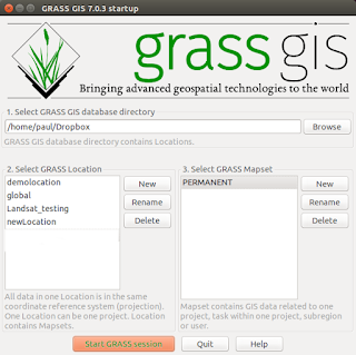
GRASS GIS is an extremely powerful application for manipulating and modelling large raster datasets such as Landsat 8 tiff bands. As GRASS users we are aware the application does not implement 'on-the-fly-projections' to ease the pain when adding data in a different projection in the way QGIS does. The grass developers insist doing so would introduce artifacts and some distortions when taking measurements off the overlayed data, so we have to deal with a 'one location = one projection/zone/datum/ellipsoid' combination. How do we get our raster images to underlay or overlay our vectors? The golden rule when using GRASS is if in doubt create a new 'location' any time you want to import or use data in a different projection. I mainly work with just two projections, EPSG:27700 (OSGB36) and EPSG:4326 (WGS 84) and In my case I would define two locations and associated mapsets, one for my everyday working projects in (OSGB36 here in the UK) and one for...
Comments
Post a Comment