Posts

Showing posts from 2016

Important GIS Application Areas

Looking for a GIS application area to work in? I stumbled across this page today. Now let your ideas flow!. http://grindgis.com/blog/gis-applications-uses  

QGIS GRASS PLUGIN 7

Image

Qgis-server...Installing the QGIS Lizmap Plugin & Lizmap Web Client

Image
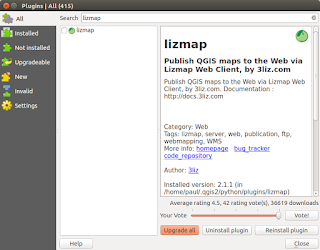
This post follows on from my previous three (most recent first in list) linked below. There is no doubt that in just a short time from now we will probably see a 'one-click' installer to by-pass the next steps but a least this method allows you to change 'in/out' the individual libraries if there is are updates using the usual ' sudo apt update && sudo apt upgrade '. http://www.paulshapley.com/2016/08/qgis-server-bringing-map-into-browser.html http://www.paulshapley.com/2016/07/how-to-install-qgis-server-on-ubuntu.html http://www.paulshapley.com/2016/04/how-to-install-postgresql-95-and.html 1.  Firstly...Create a new QGIS project, add your layers from PostGIS, Shapefiles or raster (geotiff), style and symbolise those layers, set the projection and ensure you've set up your 'OWS Server' in 'Project Properties'. 2.  Let's install the 'Lizmap' Plugin first by going into the 'Plugins' menu then 'Manage
Qgis-server...Bringing a map image into the browser on Ubuntu 16.04 LTS

Image
So you have your 'GetCapabilities' xml displaying in your browser working as in my post of Friday 22nd July 2016 http://www.paulshapley.com/2016/07/how-to-install-qgis-server-on-ubuntu.html NO?...here are some issues to check back in the QGIS project file before we move on. Check the 'Project Properties' under the 'Project' menu, go to the 'OWS server' tab. Below is an example of of how I've set up mine.  and here is the bottom bit you cannot see in the above image... Ensure under 'Save Paths' in the 'General' Tab it is set to 'relative'. Note that the layers you are going to select for the WMS service are ticked under 'Published' in the WFS capabilities table. Moving on to setting up your 'Add layer(s) from WM(T)S Server' button on the 'Manage Layers Toolbar' Ensure your url is pointing at 'http://yourhost/cgi-bin/project/qgis_mapserv.fcgi?'it i

Qgis-server...Installation on Ubuntu 16.04 LTS

Image
Before we start it is always a good idea to remove and re-install apache2 web server so that we start from the same set up:- To remove Apache2:- $ sudo apt --purge remove apache2 $ sudo apt autoremove To re-install Apache2:- $ sudo apt install apache2 $ sudo /etc/init.d/apache2 restart # or $ sudo service apache2 restart 1. $ sudo apt install apache2 (if not installed already done so as above) 2. $ sudo apt install qgis-server libapache2-mod-fcgid 3. $ sudo a2enmod fcgid 4. $ sudo a2enconf serve-cgi-bin 5. $ sudo service apache2 restart 6. add the following code and don't forget to save the changes:- ScriptAlias /cgi-bin/ /usr/lib/cgi-bin/ <Directory "/usr/lib/cgi-bin/"> Options ExecCGI FollowSymLinks Require all granted AddHandler fcgid-script .fcgi </Directory> into /etc/apache2/sites-available/ 000-default.conf $ sudo gedit /etc/apache2/sites-available/000-default.conf # so that it looks like this:- <VirtualHost *:80>   

How to install Postgresql-9.6 and PostGIS-2.3 on Ubuntu 17.04 (Zesty Zapus) in six easy steps (updated 31-05-2017).

Install Ubuntu 17.04 (Zesty Zapus) 1. check your Ubuntu version:- lsb_release -a Install Postgresql 2. On the server or your PC (Terminal):- sudo apt-get update sudo apt-get install -y postgresql postgresql-contrib Create a database and a user for access Replace DATABASE_NAME_HERE and USER_NAME_HERE with the values you want to use. # this will prompt you for a database password...also note the capital letter 'O' not number '0' (zero) below:- 3. sudo -u postgres createuser -P USER_NAME_HERE sudo -u postgres createdb -O USER_NAME_HERE DATABASE_NAME_HERE Test Connection to Postgresql 4. psql -h localhost -U USER_NAME_HERE DATABASE_NAME_HERE Postgresql will ask you for your password. Then you should see the following: DATABASE_NAME_HERE => To exit type:- \q To add PostGIS-2.3 support to the database 5. sudo apt-get install -y postgis postgresql-9.6-postgis-2.3 # typing 'postgresql-9.5' instead of postgresq

Overlaying Raster and Vector datasets with different projection parameters in GRASS GIS

Image
GRASS GIS is an extremely powerful application for manipulating and modelling large raster datasets such as Landsat 8 tiff bands. As GRASS users we are aware the application does not implement 'on-the-fly-projections' to ease the pain when adding data in a different projection in the way QGIS does. The grass developers insist doing so would introduce artifacts and some distortions when taking measurements off the overlayed data, so we have to deal with a 'one location = one projection/zone/datum/ellipsoid' combination.  How do we get our raster images to underlay or overlay our vectors? The golden rule when using GRASS is if in doubt create a new 'location' any time you want to import or use data in a different projection.  I mainly work with just two projections, EPSG:27700 (OSGB36) and EPSG:4326 (WGS 84) and In my case I would define two locations and associated mapsets, one for my everyday working projects in (OSGB36 here in the UK) and one for

The First Tablet and Full PC in One?

Could this be the first Tablet/Full PC all in one unit with Ubuntu? http://www.omgubuntu.co.uk/2016/02/bq-m10-ubuntu-tablet-everything-you-need-to-know Cannot wait to have one especially if it's under £200!

Geo For All Newsletter Archive

Those of us who need to keep up with developments in the Open Source GIS arena (osgeo.org) may be familiar with the recently posted newsletters. If you are interested i've posted the first batch here; Volume 1 No 1 - August 2015 V olume 1 No 2 - September 2015 Volume 1 No 3 - October 2015 Volume 1 No 4 - November 2015 Volume 1 No 5 - December 2015 Volume 2 No 1 - January 2016 Volume 2 No 2 - February 2016 http://www.geoforall.org/newsletters/